Lesson 5- Connecting the Pieces: Why do We Live the Way We Live?
Grade Level: 2nd Grade
Objectives:
-Students will think critically about how the Earth's geographical features affect the way people live
Essential Questions:
-How does the Earth's geography affect the way we live?
-Why do we live the way we live?
I) Standards Addressed:
Virginia SOLs:
Geography 2.5- The student will develop map skills by
a) locating the equator, the seven continents, and the five oceans on maps and globes
Living Systems 2.5- The student will investigate and understand that living things are part of a system. Key concepts include
a) living organisms are interdependent with their living and nonliving surroundings
Writing 2.11- The student will write stories, letters, and simple explanations.
a) Generate ideas before writing.b) Organize writing to include a beginning, middle, and end
National Curiculum Standards for Social Studies:
- People, Places, and Environments
- Science, Technology, and Society
- Global Connections
II) Materials for Learning Activities
A) Student Materials (per student):
1. Interactive social studies notebooks
2. Landforms handout
3. Pencils
4. Crayons or colored pencils
5. Glue sticks
B) Teacher Materials:
1. Notepad
2. 1 pen
3. Whiteboard
4. Marker
5. National Geographic’s Our World book
6. Document camera
7. Interactive social studies notebooks
8. 1 copy of the Landforms handout
III) Procedures for Learning Activities (45 minutes)
A) Introduction (10 minutes)
1. Ask students to sit on the carpet next to the whiteboard. Remind students that they have learned about the Earth, about maps that represent different places on the Earth, about continents (what we call the large land pieces on the Earth), and about countries (the unique places that are in or a part of a continent).
2. Remind students how they have also learned how our Earth was a fairly organized place, with some living things living on land and others living in the oceans or other bodies of water on Earth.
3. Tell students that today, they will be using maps and their Earth schema, or what they already know and what they have learned about the Earth, to explore how the living and non-living things on Earth affect the way we live.
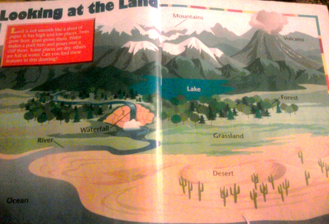
4. Open up National Geographic’s Our World book to pages 8 and 9 (see image below), which students looked at previously. After reading pages 8 and 9, write the following sentence on the board- “Land is not smooth like a sheet of paper.” Stop and ask students to explain what that may mean. Discuss the labeled land form illustrations on pages 8 and 9 to explain that the land on Earth is quite diverse.
5. Point to the sandy desert region on pages 8 and 9, and then ask students, if someone lived in this area right here, what type of weather would they have almost every day? Explain that the desert region would most likely be hot and dry, because of the lack of much precipitation like rain.
6. Ask students, if I were to draw a person who lived in this region, what types of clothes should this person wear? Should they wear a jacket and a sweater? Why or why not?
7. Ask students, what type of house do you think this person would build? If technology was available in this desert region, what do you think a person living there would want to have? (Possible suggestions may include an air conditioner, a fan, a fridge, etc.)
8. How would this person move around? With a boat, a car, or perhaps camels, which are animals that can survive without drinking water for long periods of time? Why?
9. Tell students that they will be working on an activity that will allow them to explore why people who live in different land regions live the way they do.
B) Instructional Strategies (25 minutes)
1. After you have reviewed and discussed the different land forms on pages 8 and 9 of National Geographic’s Our World book, tell students to return to their desks and to take out their interactive social studies notebooks. Pass out the handout with various land forms, which also resembles pages 8 and 9 of the Our World book.
2. Tell students that each student's handout has region of land that is readily circled for them. Tell students to look at their assigned regions of land and then draw a person that might live there in their interactive social studies notebooks. Remind them to dress their person appropriately for the weather of the region the person is from.
3. Next, tell them to extend lines from the person to create a mind map of ideas around him that answer the questions below. As you say each question, write it on the whiteboard.
- What kinds of food might this person eat?
- What might this person do for fun where he/she lives?
- What type of home would this person live in?
- How can this person move around the region they live in?
- What types of weather might this person have to prepare for where they live? How can they do so?
5. As students work on their tasks, circulate around the room to check for understanding. Take anecdotal notes and assist students as necessary.
6. After enough time has passed, ask them to finish what they are working on and to glue their landform handout into their interactive social studies notebook.
C) Summary (10 minutes)
1. Ask the students to bring their notebooks and a pencil and to have a seat on the carpet in a circle.
2. Go around the circle and have each student share which continent he/she thinks their person lives in, based on what they saw on the “Land and Water” map and why.
3. For the lesson’s reflection entry, ask the students to answer the following questions:
1. What does the place you live in look like? Describe it using helpful details.
2. How does where you live affect what you like to do and what your family usually does? (Food, clothing, shelter, leisure, etc.)
4. Remind students that they may answer their reflection entry questions by creating a web or illustrations to support their writing, if they wish to do so.
5. Commend students for their hard work and remind them to keep thinking, reading, and learning about the features of our Earth and how they affect the way we live.
7. For homework, remind students to complete their Geography and Us! Unit Study Guides to prepare for their unit test after the next review day.
8. Clean-up.
IV) Assessment
A) Teacher will listen to students’ responses, make observations, and take anecdotal notes throughout the lesson, as students work on their various activities
B) Teacher will later collect students’ interactive social studies notebooks to check their drawings, mind map webs, and reflection entries for understanding
V) Differentiation
A) Lesson includes opportunities for scaffolded expression through oral discussions, hands-on experiences, writing, and illustrating
B) Teacher may assign particular regions for students to analyze based on their abilities
C) Teacher may group and work directly with a group of students who need additional guidance or assistance
VI) Technology Integration
-This lesson requires a document camera to project an enlarged view of the Land and Water map on pages 10 and 11 of the Our World book.